More details can also be found on wikiloc links below.
https://www.wikiloc.com/hiking-trails/w4-jebel-shams-summit-oman-1-day-hike-90428668
https://www.wikiloc.com/hiking-trails/rainbow-53-jebel-shams-oman-164057907
My Non Commercial and Non Profit Hiking Community friendly personal FB Page dedicated to UAE Hiking information and Trails.
https://www.facebook.com/Patricks-Hikes-101251445547970
W4 Jebel Shams Summit: Oman
Trail Stats:
| Distance: | 24 kms |
| Difficulty: | Moderate |
| Elevation gain: | 1500 m |
| Elevation loss: | 1500 m |
| Max elevation: | 2996 m |
| Min elevation: | 1850 m |
| Trail type: | Up and Back |
| Moving time: | 7 hours 15 minutes |
W4 Jebel Shams Summit: Oman
Jabal Shams (Sun Mountain)
This is the highest peak in the Arabian Peninsula, rising to an altitude of 3,004 metres above sea level, and has a number of versants (slopes) and summits.
Jabal Shams is so called because it is the first place to greet sunlight at dawn and the last to say farewell at dusk.
Jabal Shams also hosts Al Nakhur Canyon so spectacular that it is labeled as the Grand Canyon of Arabia. Nearby is Jabal Akhdar, another prominent peak in the region.
Jebel Shams is the highest peak in Oman and across the Arabian Gulf. Translated to Mountain of the Sun, Jebel Shams is located in the Western Hajar mountain range, roughly 240km from Muscat. The mountain is one of the most popular destinations for tourists in the region, best known for breathtaking views of Wadi Ghul and Al Nakhr Canyon, often referred to as the Grand Canyon of Arabia.
Standing at 3009m tall, the temperature is cooler than that of Muscat making it a must visit destination year-round. The temperature sits around 10-15 degrees in Summer, perfect for those who would like to escape the heat whilst pursuing outdoor activities. In Winter the temperature dips and it is not uncommon to see snow at the summit, warm clothes are advisable.
The highest point of the mountain is the North Summit, which is occupied by a military base and is a restricted area. The Ministry of Tourism, Sultanate of Oman, states the North Summit to be 3,009 high.
The mountain also has second summit, the South Summit, which is publicly accessible for trekking via the W4 Trail, marked by the Oman Ministry of Tourism. The elevation of the South summit is 2,997 m high.
HIKE DETAILS:
In the past we had hiked this trail with UAE weekend lovers group from UAE under the leadership of Shan Butt. We hiked as a 2 day event by ascending on the 1st day, reaching the summit, camping at the 2800 Saddle area and returning back the next day.
This recording is of a single day fast pace hike by proper planning and endurance.
The pictures posted here are from 2 different hikes but on the same trail.
TRANSPORT:
You will need a proper 4X4 vehicle to comfortably reach the trailhead.
AWD may suffice but trying a sedan will definitely punish your car and force you to drive real slowly and lose time.
You can camp somewhere here on the Shams plateau the previous night so that you get an early start for the hike.
This point is just next to Sama resorts on the Shams plateau.
https://maps.app.goo.gl/39EhamcaqiwxEWuh9
23.227503, 57.204035
Jabal Shams, Oman
Please keep the area clean and do not litter.
The W4 trail starts almost here within 50 meters and its flag colour markers are clearly visible.
If you have a large group of hikers or visitors, there are a few basic facility guest houses scattered around bit away from the W4 trailhead.
During our another hike in the area, we stayed at this guest house.
Canyon Rest House Jabal Shams
+96897579333 (Ahmed)
https://maps.app.goo.gl/RMcpcN2wEqY6KZwx7
You will also find many other guest houses in the same area.
Please refer Google Maps for more details.
Please note that there are NO grocery shops or restaurants at this area, so you either need to carry your own food / water supplies OR arrange food with guest houses at premium prices.
EDIT 2024: There is a new grocery store opened recently here.
https://maps.app.goo.gl/y3LuQoZZhQCbNQqw8
23.217414, 57.201413
+96896296981
TRAIL:
You will need 4 Liters water per person along with other nutrients.
You can do water drops in some area (remember the location) so that you can use that water on your way back. It reduces your backpack load.
The W4 trail is clearly marked with yellow, white and Red standard flags all the length of the trail. Its easy to locate the trail all the way.
The starting point is very close to Sama Shams Resort on the plateau of Jebel shams, you can reach there by using google maps.
I started my trail for first 2 kms in a different direction, you can choose to follow that or use my descent as Ascent path as it is exactly on the marked trail.
The whole trail is on mountain surface and the surface is hard rock and stable. So no bouldering or loose rocks anywhere. Good shoes are needed and good footing too.
As you are exposed to the sun whole time, take usual precautions for sun exposure.
On the way up, after about 2.5 Kms you will be blessed with impressive views of Wadi Nakhur ( also known as Grand canyon of Oman ), Vertical cliffs and great rifts.
Its a photographers paradise.
Once you reach the Vantage point at 2800 meters elevation from where you can see Wadi Al Sahtan with impressive views. Actually you can see the South summit of Shams too.
You are actually at the base of North summit where Omani military station is based.
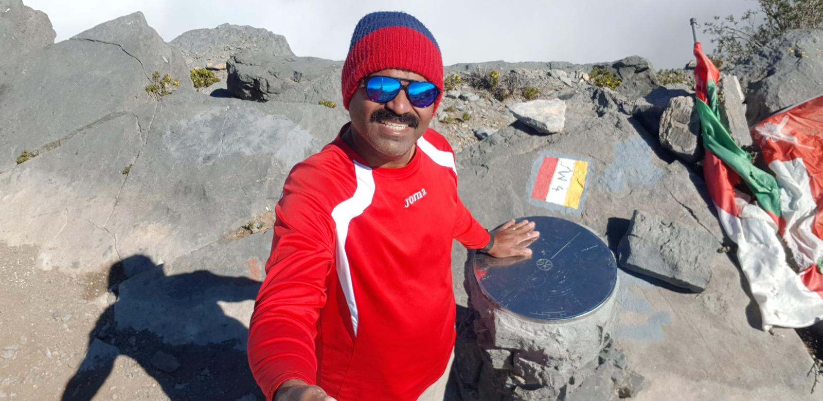
At the summit, there is a nice Summit monument with a Steel crown with all geographic information engraved and a visitor book where you can record your thoughts.
Overall an enduring hike with Gradual gradient Ascent and towards the summit last 3 Kms can be wavy kind of hike ( up and down ) gaining elevation.
When I hiked this time, it was fully cloudy and I didn’t see the canyon much. But the presence of the clouds around me made my day.
The phone data network is very limited and can not be relied upon.
One of the most scenic and breathtaking walks I’ve done in Oman.
Parking Location:
Grade: Moderate
Base Village: Sama resort
Range: Jebel Shams.
Download:

Jabal Shams compass summit

Trail

Trail.

Trail.

Trail.

Trail

Trail

Summit book


Leave a Reply