More details & pictures posted on wikiloc.
https://www.wikiloc.com/hiking-trails/kol-tor-lake-hike-kyrgyzstan-174343719
My Non Commercial and Non Profit Hiking Community friendly personal FB Page dedicated to UAE Hiking information and Trails.
https://www.facebook.com/Patricks-Hikes-101251445547970
Kol Tor Lake Hike: Kegeti : Kyrgyzstan.
Trail Stats:
| Distance: | 13 kms |
| Difficulty: | Moderate |
| Elevation gain: | 900 m |
| Elevation loss: | 900 m |
| Max elevation: | 2650 m |
| Min elevation: | 1800 m |
| Trail type: | One way |
| Moving time: | 3 hours 40 min |
Kol Tor Lake Hike: Kegeti : Kyrgyzstan.
Overview
Kol Tor Lake Hike: Kyrgyzstan with Lake Parikrama
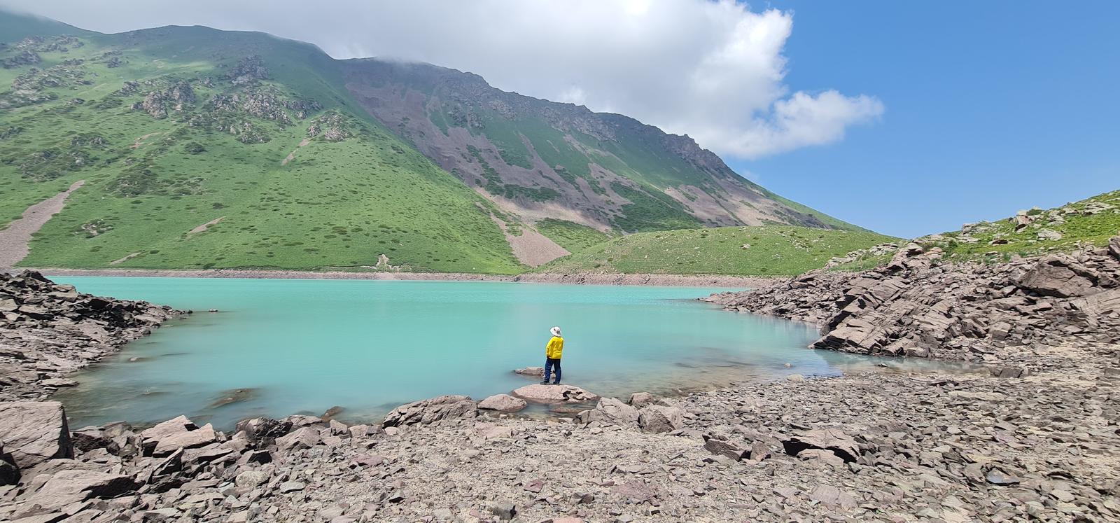
Hike up to amazing Kol Tor lake – one of the most amazingly colored lakes I´ve ever seen!
Kol Tor Lake in Kyrgyzstan is a hidden gem nestled in the mountains, surrounded by towering peaks.
Kol Tor Lake is located in the Kegeti Valley in Chuy Oblast, just 80 km from Bishkek.
Kol Tor Lake sits at around 2700m, nestled in the mountains of the Kegeti Valley in Kyrgyzstan.
The lake is coloured by loose sediment and crystal-like rocks from melting glacier waters, which give it an almost unbelievable shade of aquamarine. We’ve seen a lot of alpine lakes in our lives, but nothing quite like the colour of Kol Tor Lake!
Due to its proximity to Bishkek (it’s about 2-3 hours away), Kol Tor Lake is a popular day hike for locals. Located at Southeast of Kyrgyzstan’s capital city, Bishkek, in the Kegeti Valley (part of the Kungei Ala-Too range).
It’s also quite a short and moderate hike, meaning it can easily be done in a day and is accessible to anyone with a reasonable degree of fitness.
The best time to hike to Kol Tor Lake is between July and September, during Kyrgyzstan’s summer. During this time, you’ll have the best chances of favourable weather: warm days and cool evenings.
As Kol Tor Lake is situated at 2700m, the nights are quite cool, even during summer. Since it’s in the mountains, it’s always subject to mountain weather: heavy rain, strong winds and freezing conditions can happen at any time!
Access: Only reachable by foot or horseback, with the nearest road ending 5 km away.
Weather: Be prepared for rapid weather changes at this altitude.
Facilities: No shelter, facilities, or phone signal along the route.
The Hike Details:
Distance: 6.1 miles (9.8 kilometers)
Elevation Gain: 790 meters
Start Elevation: 1940 meters above sea level
Peak Elevation: 2730 meters above sea level
Difficulty: Moderate to Difficult
Walking Time: 4 to 6 hours
The Trail:
The trek to Kol Tor Lake starts at a yurt camp in a small clearing at the end of the road up the Kichi Kegeti Valley. The last stretch is all gravel over some larger rocks, so vehicles with low ground clearance may have to park a little before the end of the road and walk an extra few hundred meters.
The trail picks up from the yurt camp heading southwards along the east side of the small river, passing in an out of the verdant forests that line the river and climbing very briefly on several occasions to avoid small cliffs or rock falls. It carries on through this pleasant landscape for 1.7km before crossing to the west bank of the river, and after another 200m along the river begins to climb.
The first small climbing stretch of the day picks up 124m of vertical over a switchbacked half kilometer, rising to a junction of two paths. The left-hand side continues climbing directly to an open hillside, whereas the right-hand path meanders gently up a forested slope to a source for fresh water and then climbs quickly to rejoin the other path. On balance we prefer the forested route, both for diversity of terrain and for the access to fresh water, but they both eventually lead to the same place.
When the path leaves the first stretch forest, about 3km into the hike, grab water if necessary (there’s also a decent site for a tent camp here, if you’ve started quite late) and then follow the obvious trails that go off to the southeast over the open plateau area and then turn sharply to rejoin the alternate trail and re-enter the forest on a southwesterly heading.
After another short but pleasant forested section, the trail returns to the open hillsides upon which it will remain the rest of the way to the lake. Already from here, it’s easy to trace the path up the mountainside to a notch between two small hillocks, which will be the last brief climb before arriving to the lake itself. From the edge of the forest to the top of the hilltop here is around 1.5km distance climbing 300m of elevation, and this is where inexperienced groups tend to really slow down. If you visit on the same day as a tour group from the city, don’t be shy to ask them to let you pass if you catch them on this stretch.
Arriving to the shore of Kol Tor lake comes almost as a surprise – all of a sudden it just appears over the crest of the hill. Take some time for a picnic or a swim, but also be sure to wander around the lake’s shore a ways to enjoy the views that open up further up the Kichi Kegety Valley. If you’re lucky, there will also be some lovely Kyrgyz horses around grazing to add a bit more magic to the scene.
The most iconic ‘Instagrammable’ angle of the lake is from the far side, where the small stream running down the valley enters the lake itself – somehow this angle always seems to put the most emphasis on the radically turquoise hue that makes the lake so famous. If you’ve got the energy left, it’s also possible to climb a little ways up the small side valley just beyond here for higher-elevation views looking back down towards Kol Tor, but it’s considerably steeper than the trail to the lake itself.
Hiking to Kol Tor lake is navigationally easy and no special skills are required – it’s a straightforward walk along a well-worn path the whole way. However, for many casual dayhikers, this is the first trip near Bishkek that climbs any notable elevation and so some struggle with the longer uphill section.
Also note that the name “Kol Tor” is quite common in the Kyrgyz language, and there are a number of lakes across the country which the name might reference. Derived from a local word meaning roughly “place of honor”, a Kol Tor will typically be the highest lake in a chain or the last/highest lake up a valley. This Kol Tor lake, in Chuy Oblast’s Kegety Valley, is probably the most well-known among those (and certainly one of the prettiest).
Parking Location:
Grade: Moderate
Base Village: Kegeti
Range: Kol Tor
Download:

Large Cactus

Village fields

green route

trail


vegetation

mossy Trail

Trail.


Leave a Reply