My Non Commercial and Non Profit Hiking Community friendly personal FB Page dedicated to UAE Hiking information and Trails.
https://www.facebook.com/Patricks-Hikes-101251445547970
Jebel Qadaah ( Ghail Village Route )
Trail Stats:
| Distance: | 12 kms |
| Difficulty: | Difficult |
| Elevation gain: | 1143 m |
| Elevation loss: | 1143 m |
| Max elevation: | 1400 m |
| Min elevation: | 300 m |
| Trail type: | Loop |
| Moving time: | 5 hours 10 minutes |
Jebel Qadaah ( Ghail Village Route )
PLEASE READ ALL DESCRIPTION CAREFULLY.
Marked as Difficult as there are few sections of challenging terrain that needs attention.
This trail should be attempted by only experienced hikers with full knowledge of the area, fitness, terrain, mobility, skills such as scrambling and walking over loose rocks.
Please do not neglect above mentioned factors and relalities of this hike and try this ONLY if you are pro hiker with experience in all above mentioned activities.
If you need more information, please contact me directly.
If you followed my trail and my details provided have been helpful for you in your hiking journey, kindly leave a review on this post.
It helps other hikers and it will build a better hiking community. Thank you.
We referred Ben Robbins’s hike trail for our hike.
We hiked and summitted Jebel Qadaah (also known as Jebel Haqab) via the lesser hiked route of Wadi Ghail.
We deviated from Wadi Qadaah to Wadi Ghail, drove offroad as much as we could and then started our hike.
You will need a proper 4X4 to reach the trailhead or you can park AWD about 1 Km before and add the hiking distance.
Please note Sedan cars can struggle to reach the connection of Wadi Ghail with Wadi Qadaah.
You can refer the below offroading trail to access the Wadi Ghail hike start point.
https://www.wikiloc.com/offroading-trails/ghail-153559755
We parked here.
25.767852, 56.122904
https://maps.app.goo.gl/9SfvFmE8Sruf7eff8
We started the hike from Wadi Ghail (the tributary of Wadi Qadaah ) in Ras al Khaimah and hiked till the Ghail village on a visible trail with some markers and cairns.
In the midway of the hiking trail, we reached Ghail village with few houses.
From Ghail village, we proceeded by traversing along the Qadaah cliff walls to reach the saddle and further we soon merged with the well hiked Wadi Haqab Qadaah mountain trail.
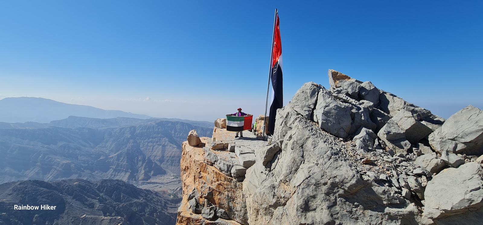
We climbed the final push thorough a steep rocky patch full of uneven boulders that took quite some time and energy and soon reached the plateau of Qadaah and soon we were at the summit with the largest mountain flag ever hoisted in any of UAE mountains.
Further we hiked northwards to reach the bit higher twin peak of Qadaah, also known as Jebel Haqab and from there we descended into the trail connecting the Hebs villages with Ghail village at the SPAR Pass.
From this point, we hiked on a proper trail all the way back to Ghail village as a loop and further descended down to our cars as per our initial ascent hike.
Overall this hike is best for good Cardio workout, good elevation gain over short distance and some of the best views from the plateau.
We could see Jebel Yabana, Jebel Rahabah, Jebel Jais, Oman Musandam range and whole of Jebel Jais area of Wadi Shah section.
Parking Location:
Grade: Difficult
Base Village: Wadi Ghail, Wadi Qadaah
Range: Jebel Qadaah.
Download:

Trail

Greenery

Trail.

Trail.

Trail.

Trail

Trail

Trail.


Leave a Reply