More details & pictures posted on wikiloc.
https://www.wikiloc.com/walking-trails/armenia-garni-symphony-of-stones-and-havuts-tar-monastery-177317513
My Non Commercial and Non Profit Hiking Community friendly personal FB Page dedicated to UAE Hiking information and Trails.
https://www.facebook.com/Patricks-Hikes-101251445547970
Garni: Symphony of Stones and Havuts Tar Monastery : Armenia.
Trail Stats:
| Distance: | 9.5 kms |
| Difficulty: | Moderate |
| Elevation gain: | 359 m |
| Elevation loss: | 359 m |
| Max elevation: | 1600 m |
| Min elevation: | 1265 m |
| Trail type: | Loop |
| Moving time: | 2 hours 10 min |
Garni: Symphony of Stones and Havuts Tar Monastery : Armenia.
Overview
During our visit to Garni town, we visited Symphony of stone park and then we further walked and hiked to Havuts Tar Monastery ruins on the mountaintop nearby.
Symphony of Stones
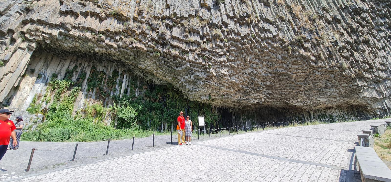
Symphony of Stones, Garni, Armenia. The columns of the cliff are about 50 meters high and are arranged in a semicircle.
The Symphony of Stones in Armenia is a well-known attraction among tourists and is recognized as one of the country’s most magnificent natural wonders. It is a favored location for hiking, picnicking, and photography. Additionally, the Symphony of Stones is a sought-after venue for weddings and other noteworthy occasions.
The Symphony of Stones formed about 40 million years ago when lava from the nearby mounts flowed down into the Garni Gorge. The lava cooled and crystallized quickly, forming the hexagonal and pentagonal columns. The columns are held in place by the weight of the surrounding rock.
Name: Symphony of Stones aka Basalt Organ
Location: Armenia, Border of Ararat and Kotayk Provinces, Gorge of Garni
Coordinates: 40.1158403, 44.7388445
https://maps.app.goo.gl/zXCnEtwEy1z6RspM6
Type: Natural monument
Distance from Yerevan: 23 kilometers (30 mins by car)
Experiencing extraterrestrial sensations does not require traveling to the planets of the solar system. You can simply stand in front of this marvelous natural creation, and instantly feel like you’re on Mars. Nature has crafted something on Earth that I believe cannot be replicated anywhere else.
Approximately 40 million years ago, the lava from the nearby mountains streamed down into the Garni Gorge, resulting in the formation of the Symphony of Stones. Images by the author of the Blog Desuden.com
The Basalt Organ, also known as the Symphony of Stones, is a stunning natural monument situated in the Garni Gorge of Armenia.
The monument is comprised of hexagonal and pentagonal basalt columns that formed from volcanic lava cooling and crystallizing. These columns are arranged in a semicircle and tower up to 50 meters in height. The monument is referred to as the “Basalt Organ” due to its resemblance to a pipe organ. It is a renowned tourist attraction and is widely considered to be one of the most magnificent natural marvels in Armenia.
Details source: Desuden.com Armenian travel blog by Vardan Papikyan.
____________________________________________________________________________
Havuts Tar translates to the “All Savior Monastery” is an 11th to 13th century walled monastery, situated upon a promontory along the Azat River Valley across from the villages of Goght and Garni in the Kotayk Province of Armenia.
The Havuts Tar Trail leads directly from the east side (left) of the reserve entrance to the monastic complex. An alternate route/shortcut that we took as our ascent route on this recording to the monastery can be found at the end of the main road along the Azat River and just past the fish hatchery ponds.
It is easily reached via the Khosrov State Reserve (which it is situated within), located across the Garni Gorge. You need to pay 3000 AMD per person as entry fees.
On this recording, we descended from this route.
It takes approximately 90 minutes to reach the ruins of the monastery via the Havuts Tar Trail. A couple of khachkars can be found midway along the trail as it forks left upon a very low mound.
Also, a short distance from the monastery (clearly visible oh a hill in the background) in a small field to the left, is a large khachkar and a small ruined monument.
Following the trail a little further leads to the fortified walls and ruins of the monastic complex.
Just before entering the monastery, a small path leads up a hill to the east and through a semi-wooded area. At the end of the path are the ruins of a small chapel with two large khachkars to the left, and a third to the right.
The majority of the Havuts Tar monastic complex was constructed between the 12th and 14th centuries.
After having been badly damaged by a large earthquake in 1679, the monastery was effectively abandoned in the years that followed.
Portions of the complex were rebuilt in the early 18th century by the Catholicos Astvatsatur Hamadantsi, and some restoration efforts took place in the early 20th century.
The eastern outcrop at Havuts Tar is surrounded by a fortified wall, constructed of roughly hewn stones that are cemented into place. There are some khachkars and other decorative stones that were used as accents and at times as rubble infill for the walls. Access to the monastery is through an arched entryway at the southeast corner that connects to the main trail. Within its confines are two churches positioned in the center (the main church with its surrounding walls intact and the ruins of another adjacent to it), the ruins of a gavit to the main church, monastic buildings situated along a section of the northern and southern interior walls, vaulted guest chambers, and a large underground chamber that likely served as a manuscript library at the south wall.
The main church is notable for the decorative relief that is found on its exterior and interior walls. There is a single entry to the church from the west through a highly decorated façade that utilizes burnt orange and dark gray tuff to highlight its unique architectural details. A similar technique is used on the interior as well. Carvings of birds adorn the tympanum above the western portal, the southern exterior wall, and one of the niches in the interior. Construction of a new church (adjacent to the north) began in 1772, but the work was never completed.
Even though much of the site is in ruins, there are still numerous inscriptions and interesting carvings to be found all over the complex. Just beyond the monastery’s walls along the path that leads to S. Amenaprkich Church and the western outcrop, are the remnants of stone foundations and depressions in the earth of other structures.
Parking Location:
Grade: Moderate
Base Village: Garni
Range: Havuts Tar
Download:

Metrology station

Lake

Summit

Base view of summit


Old Soldiers Bunker

Trail
Trail.


Leave a Reply