More details & pictures posted on wikiloc.
https://www.wikiloc.com/hiking-trails/atmar-wadi-bih-border-marker-exploration-hike-rak-204152811
My Non Commercial and Non Profit Hiking Community friendly personal FB Page dedicated to UAE Hiking information and Trails.
https://www.facebook.com/Patricks-Hikes-101251445547970
Atmar Wadi Bih Border marker exploration hike : Ras al Khaimah.
Trail Stats:
| Distance: | 17.5 kms |
| Difficulty: | Moderate |
| Elevation gain: | 900 m |
| Elevation loss: | 1050 m |
| Max elevation: | 780 m |
| Min elevation: | 160 m |
| Trail type: | Out and Back. |
| Moving time: | 8 hours 20 minutes |
Atmar Wadi Bih Border marker exploration hike : Ras al Khaimah.
This trail is definitely good for endurance as it has good amount of elevation gain over a short distance. You gain 600 meters elevation in 2.7 Kms distance. Most of this ascent trail is manmade rocky steps and stable path.
We hiked this trail to visit the UAE Oman border markers in the Wadi Bih area and towards Hebs villages.
We started our walk at 4am and reached the mountain summit in 2 hours time.
The weather was humid and breezeless in the Wadi section, but was pleasant with cool breeze in the open and mountaintop areas.
This hike starts and ends at the same spot being Up and down hike.
The location is at Wadi Bih on Jebel Jais road.
We parked here, near the Atmar village here.
Please note that this is a functional village, so pls park away from the village and do not block the access roads.
Please do not make noise, stay silent while walking through the road.
The village residents do not like loud people in their residential area.
We parked here.
25.819843, 56.113340
https://goo.gl/maps/fNdG5CXfDSGeAGue7
The first KM is just plain walk through the graded road of the village access road.
Immediately afterwards, the trail takes you through a narrow canyon all the way, winging around and gaining quick elevation but on a stable and visible path.
Finally you reach a Y junction which basically connects Wadi Bih trail, Hebs village trail and Wadi Haqab trails.
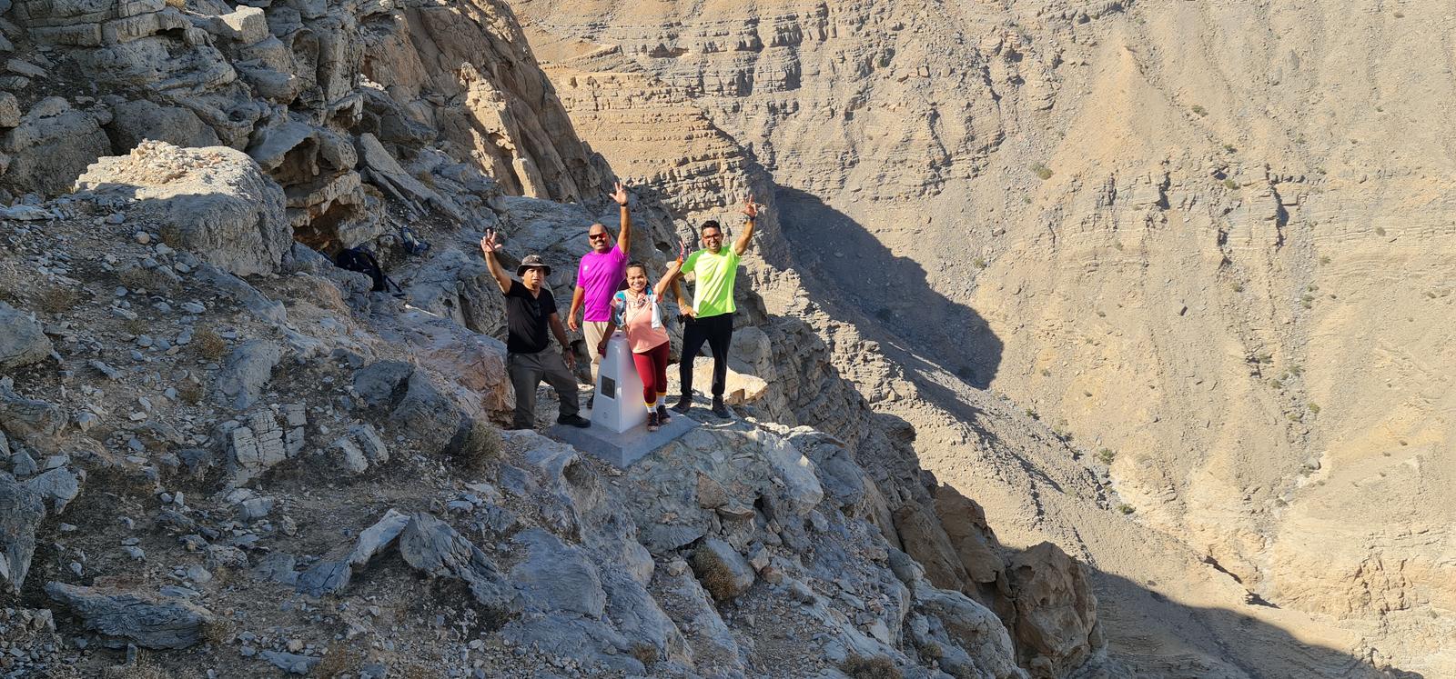
We turned left towards the mountain top to finally reach the Durdur plateau at 800 meters elevation that gives excellent views of Wadi Bih, Jebel Jais, Jebel Yabana, Jebel Qadaah and many more mountains of the Musandam peninsula.
From here, we explored the plateau to look for Oman border marker poles as recorded on this trail.
Once done, we returned back all the way on the same path.
During descent, you will be safe with good hiking shoes and a hiking pole if possible.
The narrow canyon section usually is breezeless. This Wadi is narrow and its possible that you may be saved from direct sunlight.
This trail is less popular as compared to the other trails in Jebel Jais area. Its a well laid path with a number of stairs here and there.
Overall this hike is best for good Cardio workout, good elevation gain over short distance and some of the best views from the plateau.
Stay safe, enjoy Hiking.
Disclaimer:
𝘉𝘦 𝘴𝘢𝘧𝘦, 𝘱𝘳𝘦𝘱𝘢𝘳𝘦 𝘸𝘦𝘭𝘭, 𝘋𝘰 𝘯𝘰𝘵 𝘰𝘷𝘦𝘳 𝘦𝘴𝘵𝘪𝘮𝘢𝘵𝘦 𝘢𝘯𝘥 𝘦𝘯𝘫𝘰𝘺 𝘺𝘰𝘶𝘳 𝘮𝘰𝘮𝘦𝘯𝘵𝘴 𝘪𝘯 𝘵𝘩𝘦 𝘮𝘪𝘥𝘥𝘭𝘦 𝘰𝘧 𝘯𝘰𝘸𝘩𝘦𝘳𝘦. 𝘛𝘢𝘬𝘦 𝘣𝘢𝘤𝘬 𝘢𝘭𝘭 𝘺𝘰𝘶𝘳 𝘳𝘶𝘣𝘣𝘪𝘴𝘩 𝘸𝘪𝘵𝘩 𝘺𝘰𝘶. 𝘋𝘰 𝘕𝘰𝘵 𝘛𝘳𝘺 𝘈𝘯𝘺 𝘔𝘰𝘶𝘯𝘵𝘢𝘪𝘯 𝘏𝘪𝘬𝘦𝘴 𝘐𝘧 𝘠𝘰𝘶 𝘋𝘰 𝘕𝘰𝘵 𝘜𝘯𝘥𝘦𝘳𝘴𝘵𝘢𝘯𝘥 𝘛𝘩𝘦 𝘔𝘰𝘶𝘯𝘵𝘢𝘪𝘯 𝘛𝘦𝘳𝘳𝘢𝘪𝘯𝘴, 𝘋𝘢𝘯𝘨𝘦𝘳𝘴 𝘍𝘳𝘰𝘮 𝘞𝘪𝘭𝘥𝘭𝘪𝘧𝘦, 𝘍𝘪𝘳𝘴𝘵 𝘈𝘪𝘥, 𝘏𝘺𝘥𝘳𝘢𝘵𝘪𝘰𝘯 𝘈𝘯𝘥 𝘚𝘯𝘢𝘤𝘬𝘴, 𝘠𝘰𝘶𝘳 𝘖𝘸𝘯 𝘍𝘪𝘵𝘯𝘦𝘴𝘴, 𝘙𝘦𝘮𝘰𝘵𝘦 𝘈𝘤𝘵𝘪𝘷𝘪𝘵𝘺 𝘗𝘳𝘦𝘱𝘢𝘳𝘢𝘵𝘪𝘰𝘯𝘴, 𝘊𝘰𝘮𝘮𝘶𝘯𝘪𝘤𝘢𝘵𝘪𝘰𝘯 𝘛𝘰𝘰𝘭𝘴, 𝘔𝘰𝘶𝘯𝘵𝘢𝘪𝘯 𝘎𝘦𝘰𝘨𝘳𝘢𝘱𝘩𝘺, 𝘛𝘰𝘱𝘰𝘨𝘳𝘢𝘱𝘩𝘺, 𝘙𝘪𝘴𝘬 𝘍𝘢𝘤𝘵𝘰𝘳𝘴, 𝘏𝘚𝘌 𝘙𝘦𝘲𝘶𝘪𝘳𝘦𝘮𝘦𝘯𝘵𝘴, 𝘏𝘪𝘬𝘪𝘯𝘨 𝘙𝘪𝘴𝘬𝘴, 𝘍𝘪𝘵𝘯𝘦𝘴𝘴 𝘓𝘦𝘷𝘦𝘭 𝘖𝘧 𝘛𝘩𝘦 𝘎𝘳𝘰𝘶𝘱 𝘔𝘦𝘮𝘣𝘦𝘳𝘴. 𝘚𝘵𝘶𝘥𝘺 𝘈𝘭𝘭 𝘈𝘣𝘰𝘷𝘦 𝘔𝘢𝘵𝘵𝘦𝘳𝘴 𝘞𝘦𝘭𝘭 𝘉𝘦𝘧𝘰𝘳𝘦 𝘍𝘰𝘭𝘭𝘰𝘸𝘪𝘯𝘨 𝘈𝘯𝘺 𝘛𝘳𝘢𝘪𝘭𝘴 𝘛𝘩𝘢𝘵 𝘠𝘰𝘶 𝘍𝘪𝘯𝘥 𝘖𝘯𝘭𝘪𝘯𝘦. 𝘗𝘭𝘦𝘢𝘴𝘦 𝘋𝘰 𝘕𝘰𝘵 𝘖𝘷𝘦𝘳 𝘌𝘴𝘵𝘪𝘮𝘢𝘵𝘦 𝘠𝘰𝘶𝘳𝘴𝘦𝘭𝘧. 𝘉𝘦𝘵𝘵𝘦𝘳 𝘉𝘦 𝘚𝘢𝘧𝘦 𝘛𝘩𝘢𝘯 𝘗𝘶𝘵 𝘠𝘰𝘶𝘳𝘴𝘦𝘭𝘧 / 𝘎𝘳𝘰𝘶𝘱 𝘐𝘯 𝘋𝘢𝘯𝘨𝘦𝘳 𝘈𝘯𝘥 𝘙𝘦𝘨𝘳𝘦𝘵 𝘓𝘢𝘵𝘦𝘳. 𝘓𝘢𝘵𝘦𝘭𝘺 𝘞𝘦 𝘏𝘢𝘷𝘦 𝘚𝘦𝘦𝘯 𝘈 𝘓𝘰𝘵 𝘖𝘧 𝘜𝘯𝘸𝘢𝘯𝘵𝘦𝘥 𝘏𝘪𝘬𝘪𝘯𝘨 𝘐𝘯𝘤𝘪𝘥𝘦𝘯𝘵𝘴 𝘛𝘩𝘢𝘵 𝘊𝘰𝘶𝘭𝘥 𝘏𝘢𝘷𝘦 𝘉𝘦𝘦𝘯 𝘈𝘷𝘰𝘪𝘥𝘦𝘥 𝘞𝘪𝘵𝘩 𝘉𝘦𝘵𝘵𝘦𝘳 𝘗𝘳𝘦𝘱𝘢𝘳𝘢𝘵𝘪𝘰𝘯. 𝘞𝘪𝘴𝘩 𝘠𝘰𝘶 𝘈𝘭𝘭 𝘛𝘩𝘦 𝘉𝘦𝘴𝘵. 𝘞𝘪𝘬𝘪𝘭𝘰𝘤, 𝘖𝘯𝘭𝘺 𝘍𝘰𝘳 𝘙𝘦𝘧𝘦𝘳𝘦𝘯𝘤𝘦. 𝘛𝘩𝘦𝘳𝘦 𝘊𝘢𝘯 𝘉𝘦 𝘌𝘳𝘳𝘰𝘳𝘴 𝘖𝘯 𝘛𝘩𝘦 𝘎𝘗𝘚 𝘙𝘦𝘤𝘰𝘳𝘥𝘪𝘯𝘨 𝘋𝘶𝘦 𝘛𝘰 𝘎𝘗𝘚 𝘑𝘶𝘮𝘱𝘪𝘯𝘨 𝘐𝘯 𝘛𝘩𝘦 𝘞𝘢𝘥𝘪 𝘚𝘦𝘤𝘵𝘪𝘰𝘯𝘴 𝘰𝘳 𝘌𝘳𝘳𝘰𝘯𝘦𝘰𝘶𝘴 𝘙𝘦𝘤𝘰𝘳𝘥𝘪𝘯𝘨.
Parking Location:
Grade: Moderate
Base Village: Wadi Bih
Range: Jebel Qada’ah
Download:


Trail

Trail

Trail


Trail

Trail.
Leave a Reply